

The first months of California’s winter can be described in a word that’s eluded the state for several drought-parched years: wet. Thanks to a back-to-back stream of atmospheric rivers dousing the state in record rain and snow, residents have dealt with flooding, power outages, downed trees, evacuation warnings and more than 20 weather-related deaths. Among the places that have been hit hardest: Sacramento, which has experienced major flooding; parts of coastal Highway 1,which remains closed; and the Central Coast, in particular, Santa Cruz County, which is still recuperating from serious flooding and erosion.
Winter is far from over, and it’s too soon to tell what impact the storms will have on this summer’s fire season —less dry conditions could ease the risk, or rain-spurred growth could provide more fuel and worsen it — but there are bright spots for a state that’s been coping with major drought.
“The heavy mountain snowfall is proving beneficial for Sierra resorts and skiers, and could extend the 2023 season deep into the spring,” said Caroline Beteta, the president and chief executive of Visit California, which promotes tourism in the state. “The snowpack also raises the prospect of fuller reservoirs and rivers this spring and summer.”
The recent respite from the storms offers an opportunity to assess how a month of serious weather could affect travelers in the weeks and months ahead.
An epic ski season in the Sierra Nevada
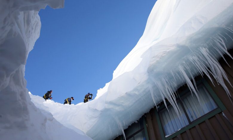
This winter is shaping up to be the kind of season that skiers and riders dream about. Mammoth Mountain, which has clocked more than 500 inches of snow at its summit so far this season, is currently “the snowiest place in North America.” Palisades Tahoe’s upper mountain is just shy of 400 inches, according to Kirstin Guinn, the marketing director of the North Tahoe Community Alliance.
“Ultimately, this has been one of the best skiing winters in memory,” Ms. Guinn said.
“We’re expecting to be skiing well past Memorial Day,” said Lauren Burke, the communications director of Mammoth Mountain Ski Area.
The storms caused major complications, including road closures and 150-mile-per-hour winds. And locals spent ample amounts of time digging out homes and businesses.
“It can feel a bit like modern pioneer living,” said Brendan Madigan, the owner of Alpenglow Sports in Tahoe City. “But the trade-off for living here is undeniably worth it.”
For Kevin Drake, a co-owner of Tahoe’s Alibi Ale Works, challenges included both the loss of weekend business and infrastructure difficulties. Closures of mountain passes, for example, prevented the delivery of ingredients for brewing and delayed beer shipments to distributors.
Travelers can expect the mountains to be busy, with traffic to match. Ms. Burke recommends visiting Mammoth midweek, and Ms. Guinn encourages downloading apps for resorts (which share current weather information and more) and checking the Caltrans website for the latest on road conditions.
A hard blow to Sequoia & Kings Canyon
A drop in elevation can be the difference between a stunning snowpack and major damage. That’s the case in Sequoia & Kings Canyon National Parks, home to giant sequoia trees and the site of the KNP Complex Fire in 2021.
The biggest issue for visitors is the closure of multiple sections of the General’s Highway, one of the park’s main roads, because of a combination of snow and rain, exacerbated by a landscape weakened by fire. This has damaged culverts and caused erosion, landslides, downed trees and flooding. Other park roads have also been affected by washouts; at least one campground was destroyed.
“We thought that this was going to be our year,” said Sintia Kawasaki-Yee, the park’s communications director, referring to the damage that the pandemic and wildfires had already inflicted. “Now, the pendulum has swung in the other direction.”
Access to the Giant Forestin Sequoia National Park could come sooner rather than later. “Public access could be restored by Feb. 11, with one lane of traffic in at least one section of the General’s Road, and another section of unpaved road,” Ms. Kawasaki-Yee said.
It’s unclear what conditions will be in the summer and how long repairs will take on other sections of the road, including the upper portion that connects Sequoia and King’s Canyon in the summer (the section is always closed in the winter).
Large portions of the park, including the location of the General Grant Tree, thesecond-largest sequoia in the world, are also accessible from the Kings Canyon side. Check the park’s website when planning your visit.
More rain does not always mean a superbloom …
Heavy rainstorms can spur hopes of a superbloom, in which parts of the California desert (like Joshua Tree and Death Valley national parks) are carpeted in wildflowers. But that’s not necessarily a given, said Ana Beatriz Cholo, a spokeswoman for the Pacific West Region of the National Park System.
“While there’s been substantial rain in many parts of California, there has not been consistent, widespread precipitation across the park to trigger such a bloom,” Ms. Cholo said. “In previous superbloom years, wildflowers had already started blooming in January.” Furthermore, as of early February, Death Valley has a low number of sprouts — not encouraging for an even average-quality bloom year.
Still, that doesn’t mean there will be no flowers. “Rainfall in the desert is often extremely localized and unpredictable,” she said, “which is what makes a true superbloom so special.”
… but may lead to a banner year for wine
While areas of California’s wine-producing regions dealt with flooding, erosion and power outages, the consensus is that the water is worth it for upcoming harvests and vintages.
“I have some friends that have dealt with some unwanted erosion,” said Grayson Hartley, the viticulturist and winemaker at Preston Farm & Winery, an organic farm and winery in Sonoma County’s Dry Creek Valley (where the creek is roaring right now). “But most of the people in my network in the wine and farming world are pretty stoked.” This is particularly the case for wineries like Preston that employ dry-farming methods, in which no additional irrigation is used on grapes.
Lester Schwartz, whose Fort Ross Vineyard & Winery’s tasting room is perched in the redwood forests above the Sonoma coast in the remote town of Jenner, emphasized how important the additional moisture is, for both the vineyards and the surrounding environment, in spite of downed trees and lost business.
“The power was out for a week to 10 days, and the internet was down at the same time as the telephones,” he said. “But ultimately, the rain is just very welcome.”
James Jelks, a winemaker and the owner of Florèz Wines, agreed that the rain was a positive, though, he added, “it’s never good to hear the stories about people getting hurt, or homes getting wiped out.”
Mr. Jelks’s winery, about 10 minutes from Santa Cruz, is in a flood zone; luckily, his winemaking operation was spared.
“One of the vineyards where I used to farm had a huge sinkhole and the road washed out,” he said. “It was definitely hectic.”
A coastal battering
Mr. Jelks’s lucky-but-hectic experience was shared by many up and down the California coast, from Santa Barbara north. Montecito, in Santa Barbara County, issued an evacuation order in a frightening echo of the devastating landslide in 2018. Fortunately, this winter, the area emerged relatively unscathed, largely because of flood control measures.
“This was really a threefold disaster,” said Chad Nelsen, chief executive of the Surfrider Foundation. “There were sewage treatment plants failing from San Diego to San Mateo. There was an incredible amount of debris and plastic pollution washed up on the beaches. And there was a ton of coastal erosion and flooding.”
Santa Cruz County experienced the most visible damage as flooding rivers combined with large ocean swells. West Cliff Drive, which hugs Santa Cruz’s coast, partly collapsed. The town of Capitola was besieged by a section of collapsed wharf and much debris, which crashed into waterfront businesses. Smaller towns in the Santa Cruz Mountains experienced flooding, downed trees, mudslides and power outages. Still, the majority of the area is “open for business,” said Michael Martelon, the chief executive of Visit Santa Cruz County.
“We did not get washed away,” he said. “In Capitola, less than 1 percent of the businesses in the city and 10 percent of businesses on the esplanade have been affected. And they’re working hard to be back open by Memorial Day.”
Some areas may take longer, like the Capitola Wharf, which will take at least a year to rebuild. (Renovations were already scheduled for this fall.)
Big Basin Redwoods State Park is currently closed because of storm damage; most other area state and county parks and beaches are at least partly open.
Dylan Linde, the manager of the Santa Cruz outlet of the Traveler Surf Club & Coastal Outpost chain, said that while the shop itself was fine, much of the staff was affected, including him.
“I live in the mountains, where there was a huge mudslide, and a neighbor had a redwood tree land on his house,” he said. “I lost power for eight days.”
Farther north, on the Mendocino coast, the area’s isolated feel was heightened during the storms. “There are limited ways in and out,” said Matthew Kammerer, the chef at the Harbor House Inn, in the town of Elk, which can be reached only via hairpin turns on coastal Highway 1 or through winding redwood forest roads. Two of those routes, including a portion of Highway 1, were closed for days.
While this storm was major, it wasn’t unprecedented — Harbor House had already made the decision to close its restaurant during January, largely because of safety considerations for the staff. The hotel itself remained open.
“We weren’t telling guests not to come, but we were telling them that it was dangerous,” Mr. Kammerer said. “We turned Harbor House into a bit of a safe haven for our staff, and opened it up for them to come stay, or cook a meal.”
A similar feeling of community and resilience is pervasive in Big Sur, along the winding, magnificent Central Coast south of Monterey. The storms have led to the closure of a portion of Highway 1, which could cut off access from the south for months. Julia Pfeiffer Burns State Park, a hiking and camping destination, sustained major damage, as did others in the area. But the local community is coping.
“We’ve learned how to deal with events like this through hard-won experience,” said Kirk Gafill, the general manager of Nepenthe, a restaurant overlooking the Pacific that has been operated by his family for 74 years. “Things are more challenging here because of distance and lack of infrastructure, but that’s exactly what drew a lot of people to the area in the first place.”
This understanding that California’s beautiful, wild places can be particularly vulnerable is a sentiment shared by those who live and work there. Particularly when there are silver linings, like an epic spring surf season up and down the coast.
“It’s literally waves and wipeouts,” said Rel Lavizzo-Mourey, who owns the Traveler Surf Club & Outpost chain with her partner, Julie Cox, a former professional longboard surfer. “You’re trying to figure out how to stay ahead of nature, stay safe and also enjoy it.”
Follow New York Times Travel on Instagram, Twitter and Facebook. And sign up for our weekly Travel Dispatch newsletter to receive expert tips on traveling smarter and inspiration for your next vacation. Dreaming up a future getaway or just armchair traveling? Check out our 52 Places to Go in 2023.